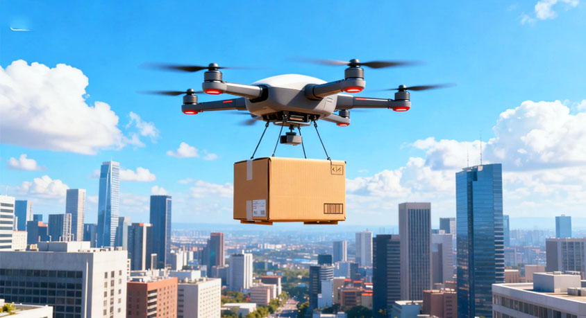
The familiar buzz overhead is no longer just a distant plane or a hobbyist's weekend project. It's a scheduled, autonomous delivery drone descending on your neighbor's driveway. You watch it lower its package with mechanical precision before climbing back to its cruising altitude of 100 to 400 feet. The transaction is efficient and silent. What is not silent, in a data sense, is the constant stream of visual and location information its onboard systems are collecting. The drone is not a flying postman; it is a mobile sensor platform on a commercial mission. Its primary sensor—a high-resolution navigation camera—sees everything below its flight path. In 2026, the privacy crisis is not a single drone capturing a sensitive moment, but the aggregate, persistent mapping of private spaces by a fleet operating on daily routines.
Technically, the drone's vision system is its fundamental navigational tool. Think of it not as a camera, but as the machine's primary eye for obstacle avoidance, landing site verification, and GPS-correlated positioning. It must see clearly to operate safely. This creates an inherent and massive data collection exercise. A drone flying a prescribed route to your neighbor's house captures your backyard swimming pool, your new patio construction, the cars in your driveway, and the layout of your property. While companies state this data is used only for navigation and promptly deleted, the raw footage exists, however briefly, on the drone's storage and in transmission logs. The legal concept of "curtilage"—the area immediately surrounding a home where privacy is reasonably expected—has not been meaningfully updated for an era of routine commercial overflight at low altitudes.
The risk evolves from incidental capture to systematic aggregation and inference. A single image is a snapshot. The daily or weekly flight path of multiple drones from the same or different services creates a time-lapse map of your life. Algorithms can detect changes: a new expensive car, a persistent patio furniture set indicating wealth, a child's playset appearing, or even patterns of activity. This aggregated data, stripped of directly identifiable information like your address but tied to a geographic coordinate, is immensely valuable for other commercial purposes: property valuation, insurance risk assessment, or targeted advertising. Your physical life becomes a data layer in a commercial aerial database.
The legal framework is critically outdated. The seminal case of Florida v. Riley (1989) held that police observation from 400 feet in a helicopter did not violate the Fourth Amendment, as that airspace was publicly navigable. Delivery drones now operationalize this precedent for commercial entities. Your backyard is potentially "in plain view" from a navigable air corridor dozens of times a day. Current privacy policies rely on corporate self-restraint, not legal prohibition, against using this data beyond operational needs. The enforcement mechanism is opaque.
Therefore, your defensive protocol must be proactive and layered. First, implement physical obstructions. Invest in architectural privacy screens, pergolas with solid roofs, or strategically planted tall tree canopies. The goal is to break the sightline from a steep angle, creating visual "shadows" over sensitive areas like pools, hot tubs, or secluded patios. Second, employ electronic detection and notification. Use a hobbyist-grade drone detector that listens for the distinct RF signals of common delivery drone models. When a detection alert sounds, it is a cue to pause sensitive outdoor activities, much as you would pause a conversation when someone walks nearby. Third, engage in legal and policy advocacy at the municipal level. Demand that local ordinances require all commercial drone operators to implement and respect dynamic geofencing. This technology would allow homeowners to register a digital "privacy volume" over their property (e.g., a 150-foot high cylinder). While it wouldn't block flight paths, it would mandate that drones operating within that volume disable all non-essential data recording and transmission, with compliance cryptographically verifiable.
The era of aerial convenience is also the era of aerial observation. You cannot stop the flight path, but you can control what is visible and valuable from it. Your strategy is to obscure, detect, and legally restrict data capture. Treat your property's airspace as an extension of your digital perimeter. Assume every routine overflight is a data collection event. Your privacy will be determined by the technical and legal barriers you erect before the first drone's camera processes its first frame. Act on the assumption that the sky is no longer empty; it is a data-gathering layer. Plan your defenses accordingly.
Disclaimer: Mention of any brand or trademark is for identification only and does not imply partnership or endorsement